Hiking & Biking
Step Into the Wild
The Land Between the Lakes offers a diverse trail system for both hiking and biking enthusiasts. Explore over one hundred miles of trails and two-hundred miles of scenic roads, where the journey is as rewarding as the destination. These paths are your ticket to discovering some of the most serene spots in the area.
Explore LBL’s many trails by clicking on a heading below. In addition to descriptions and details, you’ll find lots of useful information and links to any permits or reservations you may need for your trip.
Trail Rules
1. Campfires permitted in previously used sites except during high fire danger. Dead or down wood may be used for fuel. Attend fire at all times and completely extinguish before leaving.
2. Respect the Resource
– Camp at least 50 feet from marked trail. Bury all human waste 200 feet from marked trail.
– Leave plants, flowers, and historic items behind for others to enjoy.
– Do not harass, feed, or approach wildlife.
– Use low-impact techniques. Please stay on trails to prevent soil erosion, even through wet areas.
– Pack out all garbage. Recycle bins located at Golden Pond Visitor Center, Homeplace, Nature Station, and North & South Welcome Stations.
– Motor vehicles prohibited except approved organized events.
3. Overnight camping requires purchase of a permit or nightly camping fee.
4. Pets must be on a leash of six feet or less and under physical control at all times. Pet waste must be disposed of properly by the owner.
5. Call Before you Haul: Check trail conditions at 270.924.2000 or the Forest Service Alerts page.
6. You are responsible for your own safety. Inherent risks exist. Be prepared for a variety of unexpected and dangerous conditions.
– Protect yourself from Lone Star and American Dog ticks, primarily from March through October. Insect repellent is available in our gift shops.
– Be familiar with poison ivy and avoid it.
– Cell service is spotty and unreliable. Let a family member or friend know where you will be, your contact information, when you plan to arrive and return, and who is coming with you.
– For 24-hour dispatch, call 1.877.861.2457.
– Call 9-1-1 in an emergency.
Hiking, Biking, Horse-riding, and OHV Trails
Click on a trail heading below for details and map
Canal Loop Trail System
| DETAILS | FACILITIES | NOTES |
| Length ~11 miles plus 3 miles of connector trails Trailheads North Welcome Station Difficulty Recommended Seasons |
Parking
Accessible restrooms, Picnic areas, grills Backpacking and overnight camping allowed. |
Water is not available on trails. Springs are not reliable.
Bring water or filter lake water. Potable water is available at North Welcome Station and Hillman Ferry Campground. |
Trail Map (Download PDF)
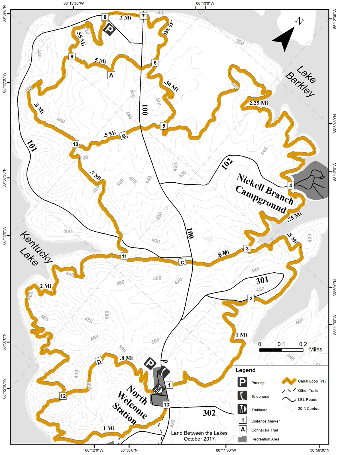
Canal Loop Trail | 11 mi
The Canal Loop Trail is a fast single track trail for mountain bikers with challenging hills on the Kentucky Lake portion of the trail. The trail crosses multiple creeks, old homesites, and forest roads. Canal Loop Trail offers opportunities to access both lakes’ shorelines.
Canal Loop Trail A Connector
The A Connector is a .5-mile trail, but when combined with a portion of the Canal Loop, forms a 1.4-mile loop that starts and finishes at Kentucky Lake Scenic Drive.
Canal Loop Trail B Connector
The B Connector is a .5-mile trail that can have loops made from either the south or the north. The trail intersects Woodlands Trace.
Canal Loop Trail C Connector
The C Connector is an interior .6-mile trail that takes users through stream sides and old homesites. The C Connector can only be accessed by traveling the Canal Loop Trail.
Canal Loop Trail D
The D Connector is .8 miles long and is accessed from the North Welcome Station. This trail grants access to the Canal Loop Trail, North/South Trail, and the North End Paved Trail.
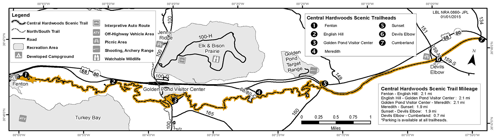
Central Hardwoods Scenic Trail
| DETAILS | FACILITIES | NOTES |
| Length ~11 miles total (2.5 miles paved on the east side beginning at Lake Barkley, and the remaining 8.5 miles compacted stone west to Kentucky Lake) Surface Type Difficulty Recommended Seasons |
Parking
Accessible restrooms Picnic area with grills Pavilion Vending machines at Golden Pond Visitor Center Pavilion with grills and vault toilet at Fenton |
The Central Hardwoods Scenic Trail is a multiple-use trail. Bikers and hikers share the entire length of the trail. |
Trail Map (Download PDF)
Click image to enlarge
Trailheads
1. Fenton Campground | Compacted stone & moderate
2. English Hill | Compacted stone & moderate
3. Golden Pond Visitor Center | Compacted stone & moderate
4. Meredith | Compacted stone & moderate
5. Sunset | Asphalt & easy
6. Devil’s Elbow | Asphalt & easy
7. Cumberland | Asphalt & easy
Trailhead Information
Fenton – (located at Fenton Campground) Begin your hike at one of the first recreation areas established in Land Between the Lakes.
English Hill – (located on FS RD US68/KY80-B) This rise is known locally as English Hill, named for Mary and M. E. English, the family that once lived there.
Golden Pond – (located at Golden Pond Visitor Center) Learn more about Land Between the Lakes here. Exhibits, an observatory, and planetarium also add to your experience.
Meredith – (located on FS RD US68/KY80-C) Named for nearby Meredith Cemetery. The Meredith family used a jenny (female donkey) instead of horses. They used them to plow, ride, and hitch them to wagons or buggies.
Sunset – (located on FS RD 160 & US68/KY80) Just home from WWII in 1947, two local brothers, Conley and Lew Wallace, built the Sunset Inn (which was located here). Both served in the Pacific during WWII. Conley named it the Sunset Inn for the “setting sun” shoulder patch insignia on his 41st Infantry Division uniform.
Devil’s Elbow – (located on FS RD 159 & US68/KY80) In the days of steamboats, the community of Golden Pond was served by a landing on the Cumberland River known as Devil’s Elbow, so called because of the large bend in the Cumberland River here.
Cumberland – (located on FS RD 134 & US68/KY80) The area, named for the river and the community which had been located on the western shore of the river just north of the bridge, is now covered by Lake Barkley.
Energy Lake Trail
| DETAILS | FACILITIES | NOTES |
| Length 4.6 mile loop Trailhead Difficulty Recommended Seasons |
Parking
Accessible restrooms Developed camping Trail Markings |
Water is not available on trails. Springs are not reliable.
Bring water or filter lake water. Potable water is available at North Welcome Station, Golden Pond Visitor Center, and Energy Lake Campground. |
Trail Map (Download PDF)
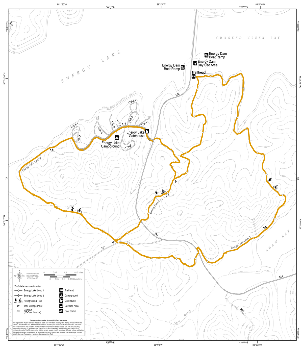
Additional Lake Energy Rules
Overnight camping is only permitted at Energy Lake Campground.
Backpack camping is not allowed along the trail.
All Back Country Camping campsites must be at least 50 feet from the marked trail.
If camping as a Back Country camper, each person 18 and over must purchase a Back Country Camping Permit.
Fort Henry Trail System
| DETAILS | FACILITIES | NOTES |
| Length ~30 miles Trailhead South Welcome Boswell Landing Piney Campground Difficulty 250+ foot change ~ 30 miles of Recommended Seasons |
Parking
Accessible Picnic area |
Water not available on trails.
Springs not reliable. Bring water or filter. Potable water at South Welcome Station or Piney Campground. |
Trail Map (Download PDF)
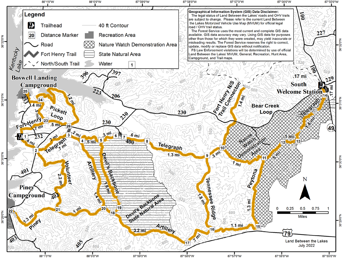
Artillery Trail | 17, 18, 20, 4 | 4.6 mi
Follows historic wagon road used by Ulysses Grant and his troops heading to Fort Donelson. Begins at Telegraph Trail and gradually rises in elevation. Flattens out along ridgeline then drops to meet Peytona Trail.
Devils Backbone Trail | 5, 19, 18 | 1.6 mi
Follows along a ridge overlooking opposing hollows. In places, the knife-edge ridge is barely wider than the trail itself. Look for mountain laurel on the bluffs.
Peytona Trail | 11, 15-17 | 3.9 mi
Pass along old home sites and beaver dams. You may notice remnants of the 1800’s iron industry.
Pickett Loop | 23, 24, 26 | 2.2 mi
Pass along old home sites and offers views of Kentucky Lake. It can be easily accessed at the Fort Henry Trailhead or Boswell Landing Campground.
Piney Trail | 20-22 | 2.3 mi
Access from Piney Campground. Starts in bottomland and ascends to a ridge top to meet the Volunteer Trail, as well as General Grant’s historic route, the Artillery Trail.
Telegraph Trail | 1-14 | 7.5 mi
Longest trail in Fort Henry Trail System and connects with other system trails. Follows along stream sides and creeks, climbs ridges, then heads back down along the streams. Old home sites, cemeteries, springs (seasonal), and beaver dams.
Tennessee Ridge Trail | 9, 16 | 1.8 mi
Easy trail traces the physical divide between the Cumberland and Tennessee River watersheds. Lays farthest interior, providing the best opportunities for solitude.
Volunteer Trail | 2, 21 | 2.2 mi
Travel through bottomland hardwoods. Connects Telegraph and Piney Trails.
Hillman Heritage National Recreation Trail
Within the woods of Hillman Ferry Campground is the Hillman Heritage National Recreation Trail. This trail system often follows historic roads used by the former Star Lime Works community which was the site of a thriving lime industry that began some time before the Civil War.
The community survived through changes in lime works ownership and many economic fluctuations in the production of lime and limestone, until it was disbanded sometime after 1945 due to construction of the Kentucky Lake Reservoir.
Star Lime Works is being recorded as a historic district and the remaining cultural features, landscape, and history are portrayed through interpretive stops along the trail.
The trails are open for hiking and biking to Hillman Ferry Campground campers and the general public.
| DETAILS | FACILITIES | NOTES |
| Length ~5.5 miles Difficulty For biking, the trails are difficult to navigate through. |
Heritage Trail markers and interpretive signs
Vista Overlook markers |
Water not available on trails.
Springs not reliable. Bring water or filter. Potable water at South Welcome Station or Piney Campground. |
Trail Map (Download PDF)
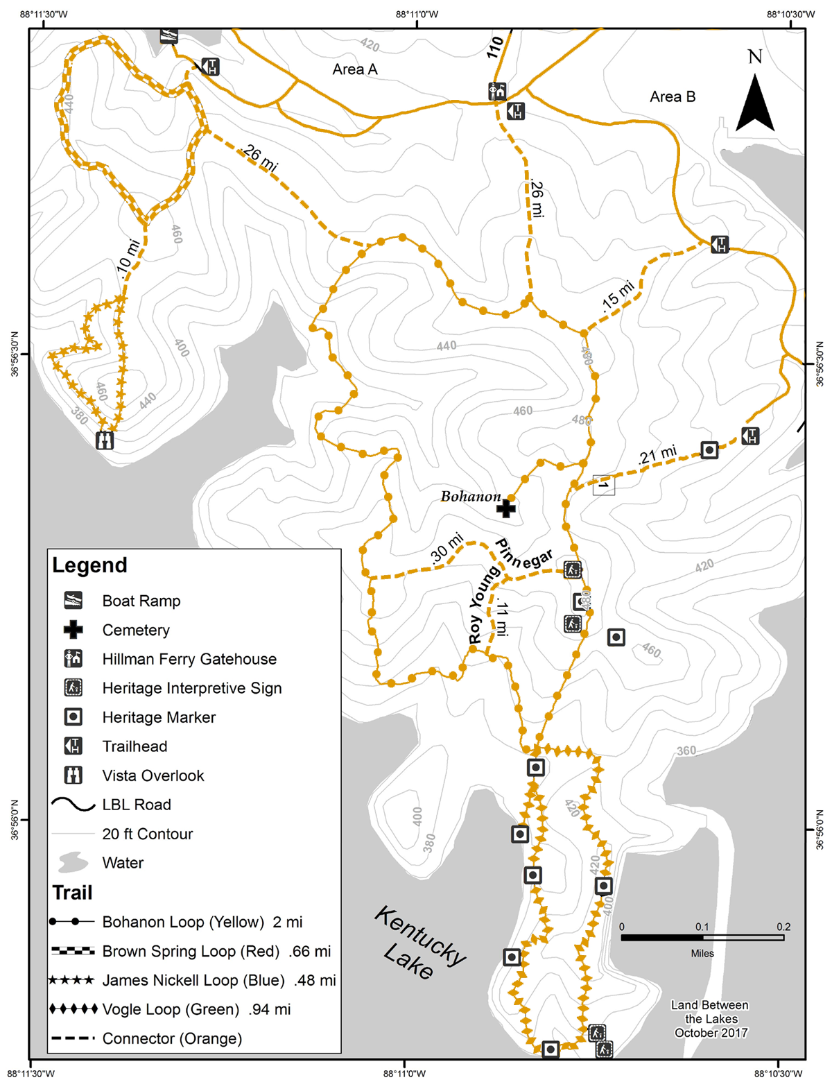
Bohanon Loop | 2 mi | Easy
This is the longest of the trails in this system. This main loop trail provides access to Brown Spring Loop, James Nickell Loop, and Vogle Loop via connector trails. This trail takes you up and over ridgelines and offers users an excellent opportunity to view wildlife.
Brown Spring Loop | 0.66 mi | Easy
Winding its way through mature hardwood stands and meanders up and down ridgelines. This trail can be used for a short hike or can be linked up with the James Nickell Loop or Bohanon Loop to add to the length of your hike. This trail can be accessed via Bohanon Loop or the Trailhead near the boat ramp in Area A.
James Nickell Loop | 0.48 mi | Easy
Hikers can visit a scenic overlook of Kentucky Lake. The trail follows the ridge top along the edge of Kentucky Lake and then dips back into the bottoms. This trail is accessible via the connector trail from Brown Spring Loop.
Vogle Loop | .94 mi | Easy
Notice the heritage markers along the way that takes you to a primitive rock beach on Kentucky Lake. Vogle Loop is accessed via Bohanon Loop. Vogle Loop takes hikers past an old home site and limestone quarry associated with the Star Lime Works District. Stop along the way to learn about the history of the area.
Nature Station Trails
Center Furnace, Hematite, Honker, Long Creek, and Woodland Walk
The Nature Station Trail System offers family-friendly hiking trails with easy-to-find trailheads and parking. Trails meander around the 8,500-acre Woodlands Nature Watch Area.
This area hosts some of the best opportunities to view wildlife in the region because of the diverse terrain of prairie, wetlands, lakeshore, upland, and bottomland forests.
Nature Station Trails also connect with the North/South Trail. Close to 260 species of birds and 55 species of mammals have been documented in Land Between the Lakes.
| DETAILS | FACILITIES | NOTES |
| Length ~8 miles Difficulty Trail Surface Dirt, pavement |
Picnic tables and toilet facilities at entrance to Hematite Lake |
Nature Station trails are open to foot traffic only |
Trail Map (Download PDF)
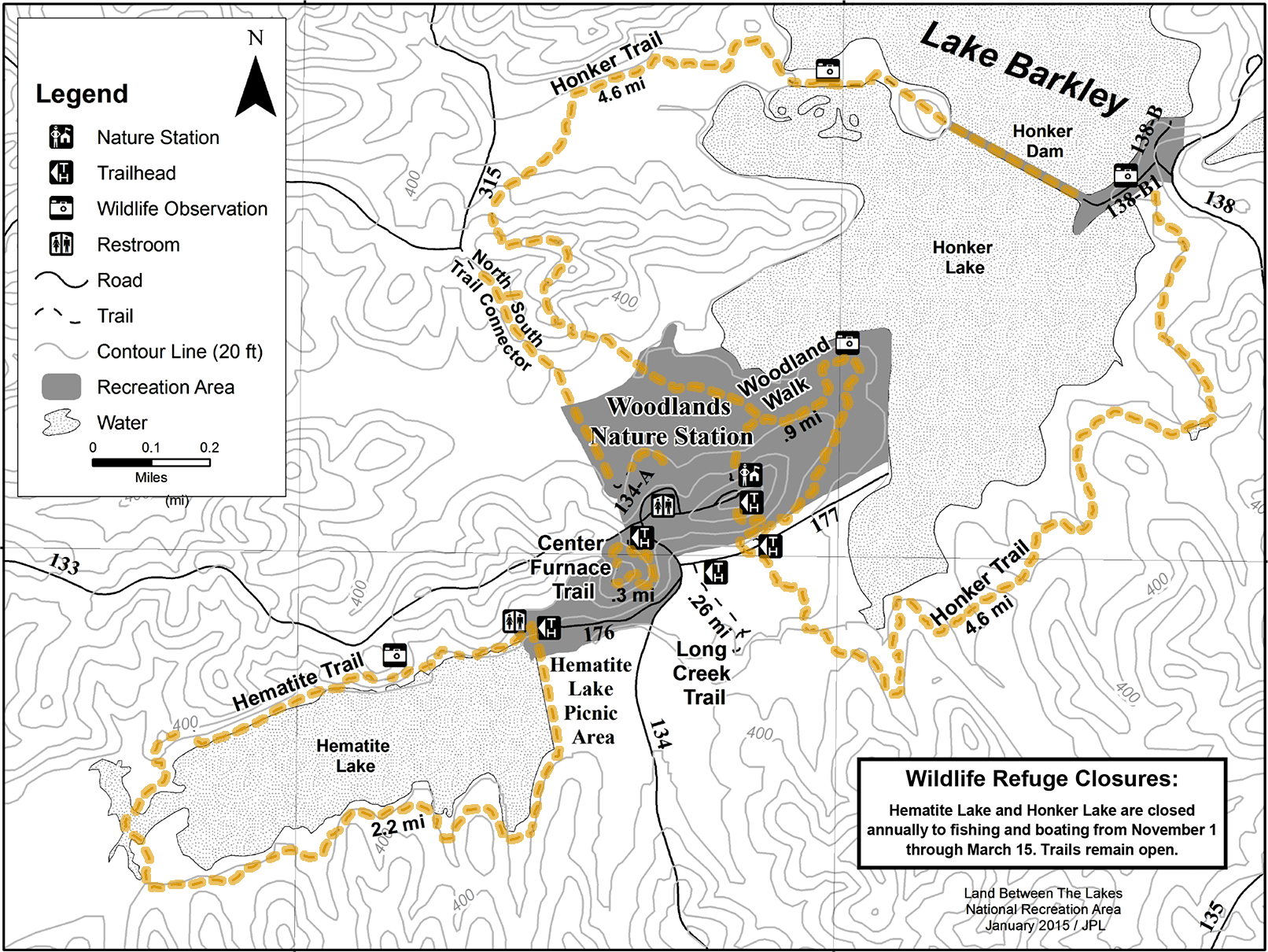
Center Furnace Trail | 0.3 mile, 30 minutes | Easy, mainly flat; some stairs
On this interpretive trail, you will see evidence of how this busy community thrived over 150 years ago and the impact the iron industry had on the land and its people.
Hematite Trail | 2.2 miles, 1 hour 30 minutes | Easy to Moderate: flat along woods, boardwalk, and lakeshore; some hills
Great trail for wildlife viewing including birds and plant life along the lakeshore and marshland. Trail includes a board walk and scenic overlook of the lake. Find picnic tables and toilet facilities at entrance to Hematite Lake.
Honker Trail | 4.6 miles, 3 hours | Easy to Moderate: moderate hills and ridges; flat lakeshore meadows
Named after Canada geese, this loop meanders near the shoreline and through forest and fields. Look for deer, osprey, bald eagles, beavers, and Canada geese. Check out the views from the dam.
Long Creek Trail | 0.26 miles, 20 minutes | Easy: flat, paved, and accessible
Boasting a rich variety of plant life, this trail provides paved access for visitors to view a bottomland hardwood forest along a creek. The area serves as a favorite feeding and resting spot for wildlife.
Woodland Walk Trail | 0.9 miles, 1 hour | Easy to Moderate: meanders around Nature Station and provides access to Honker Lake and trail
Beginning and ending at the Nature Station parking lot, this trail brings you through scenic woodlands and offers several scenic lookouts onto Honker Lake. Perfect for groups.
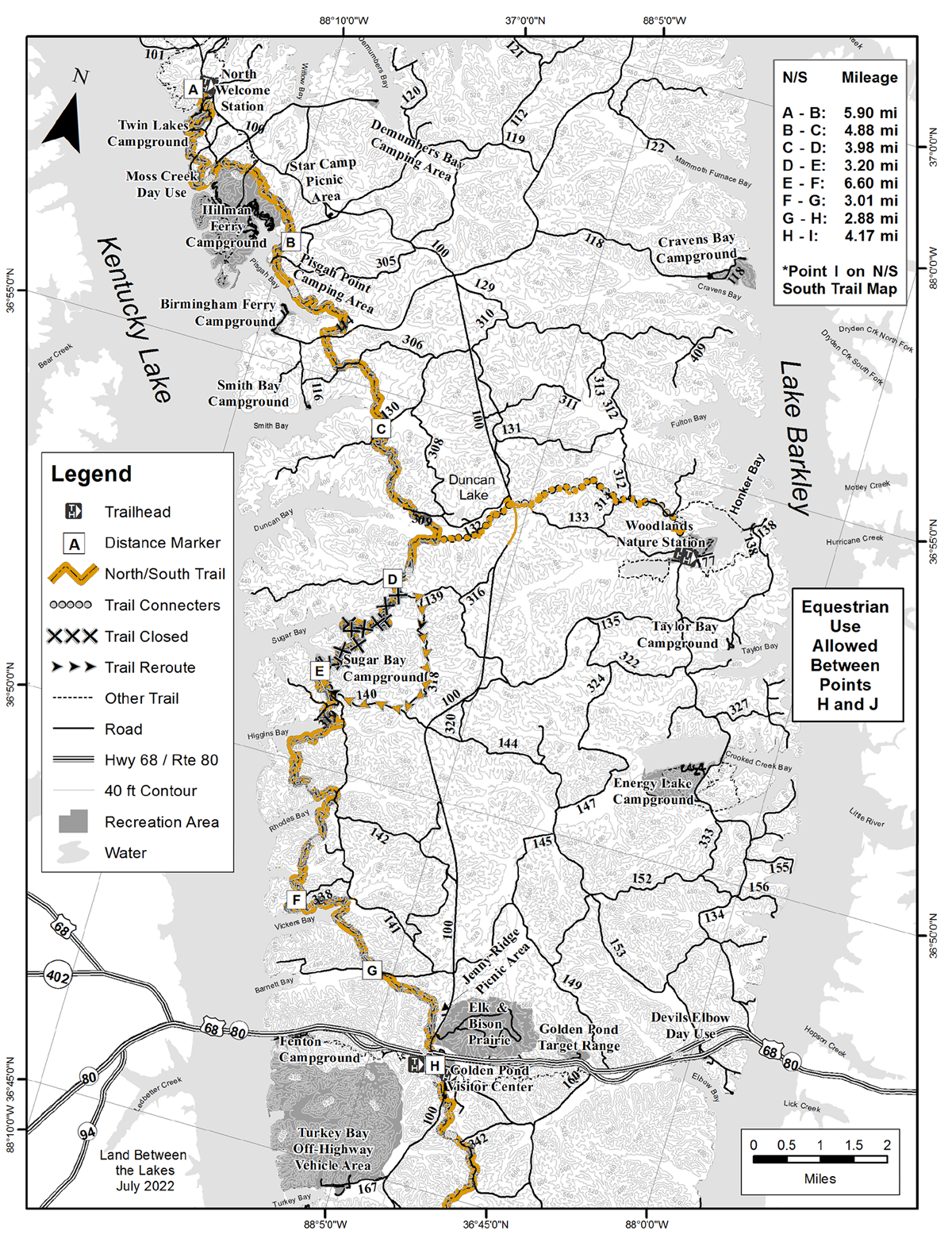
North/South Trail - North End
The North/South (N/S) Trail spans the entire length of Land Between the Lakes. The northern portion consists mainly of single-track trails meandering from shoreline to heavily wooded ridges and a connector trail to the Woodlands Nature Station.
The trail provides stretches where users walk parallel to Kentucky Lake and sweep into large bottoms offering a sense of solitude.
The N/S Trail intersects many Forest Service roads allowing for loop opportunities and access points to hike or backpack the trail piece by piece.
| DETAILS | FACILITIES | NOTES |
| Length 31 miles Difficulty Trailheads Golden Pond Visitor Center |
Parking
Accessible restrooms Picnic area with grills at Golden Pond Visitor Center and North Welcome Station Basic/dispersed camping Trail markings |
This is a multiple-use trail for bikers, hikers, and backpackers.
Mountain biking is discouraged during Horses are not allowed on the North End of Water is not available on trails. Springs are not reliable. Bring water or filter lake water. Potable water is available at South Welcome Station and Piney Campground. |
Trail Map (Download PDF)
Backpacking
Overnight camping is permitted along the North/South Trail.
All campsites must be at least 50 feet from the marked trail.
If camping in a designated Basic Campground, each person must purchase a Basic Camping Permit.
North/South Trail - South End
The North/South (N/S) Trail spans the entire length of Land Between the Lakes.
The southern portion consists mainly of old, double-track roadbeds interspersed with some single-track corridors.
The trail meanders over and through heavily wooded ridges, wildlife clearings, and mature bottomland hardwood stands.
The southern portion has two backcountry shelters for overnight camping. Approximately 11 miles are “multiple-use” whereby hikers, backpackers, and equestrians share the trail.
The N/S Trail intersects Forest Service roads offering several loop opportunities and access points to hike the trail piece by piece.
| DETAILS | FACILITIES | NOTES |
| Length 27 miles Difficulty Trailheads Golden Pond Visitor Center Homeplace 1850s Working Farm South Welcome Station |
Parking
Accessible restrooms Picnic area with grills at Golden Pond Visitor Center and North Welcome Station Basic/dispersed camping Trail markings |
This is a multiple-use trail for bikers, hikers, and backpackers.
Mountain biking is not allowed on the South End of the North/South Trail. Horses are allowed on certain sections of the South End of North/South Trail. Water is not available on trails. Springs are not reliable. Bring water or filter lake water. Potable water is available at South Welcome Station and Piney Campground. |
Trail Map (Download PDF)

Overnight camping is permitted along the North/South Trail. All campsites must be at least 50 feet from the marked trail.
If camping in a designated Basic Campground, each person must purchase a Basic Camping Permit.
A permit is required for each horse trailer entering Land Between the Lakes. Purchase permit online or at Wranglers Campground.
Turkey Bay Off-Highway Vehicle (OHV) Trails
Turkey Bay Off-Highway Vehicle (OHV) Area provides 100 miles of designated trails for off-road riding and camping. Centrally located, Turkey Bay offers a variety of topography and trails for everyone.
All riders must sign a liability waiver. By signing, registrants agree to obey all rules and regulations posted at Turkey Bay OHV Area and on Land Between the Lakes’ literature and website. The permit holder is responsible for all use of registered vehicle, ensuring it is operated in a safe and prudent manner at all times.
Trails may close if the ground is saturated in order to prevent resource damage
| DETAILS | FACILITIES | NOTES |
|
All trails are two-directional. Primary Trails | Yellow These maintained trails offer novice riders pleasant, less-challenging riding opportunities. Secondary Trails | Orange These narrow and more challenging trails serve as connectors between primary trails. Tertiary Trails | Blue The narrowest and most challenging trails serving as connectors between both primary and secondary trails. Challenge Areas These areas offer our most difficult trails and are typically 2-10 acres of steep, washed-out hill climbs. Although individual trails within our Challenge Areas will not be marked, boundaries are marked by red rings on the trees. Only ride on trails already disturbed Trailheads Golden Pond Visitor Center |
Please read our sign and instructions at entrance. Turkey Bay offers basic amenities for a nightly, per camping-unit fee. Camping at Turkey Bay: Choose a campsite, fill out a provided fee envelope, insert camping fee into the envelope, and deposit the envelope in the honor fee tube at the entrance. Please do this within 30 minutes of choosing your site. Two 24-hour generator areas, chemical toilets, and drinking water are available for our guests. Ice is available for purchase at the gatehouse. If the gatehouse is not staffed, purchase your riding permit at Golden Pond Visitor Center. |
Please read our sign and instructions at entrance. Camping registration is self-service at the information kiosk by the gatehouse. For faster registration, print and fill out the Turkey Bay Off-Highway Vehicle Area Registration and Liability Waiver Form. Bring the form to either Turkey Bay OHV Area Gatehouse or Golden Pond Visitor Center to register.
|
Trail Map (Download PDF)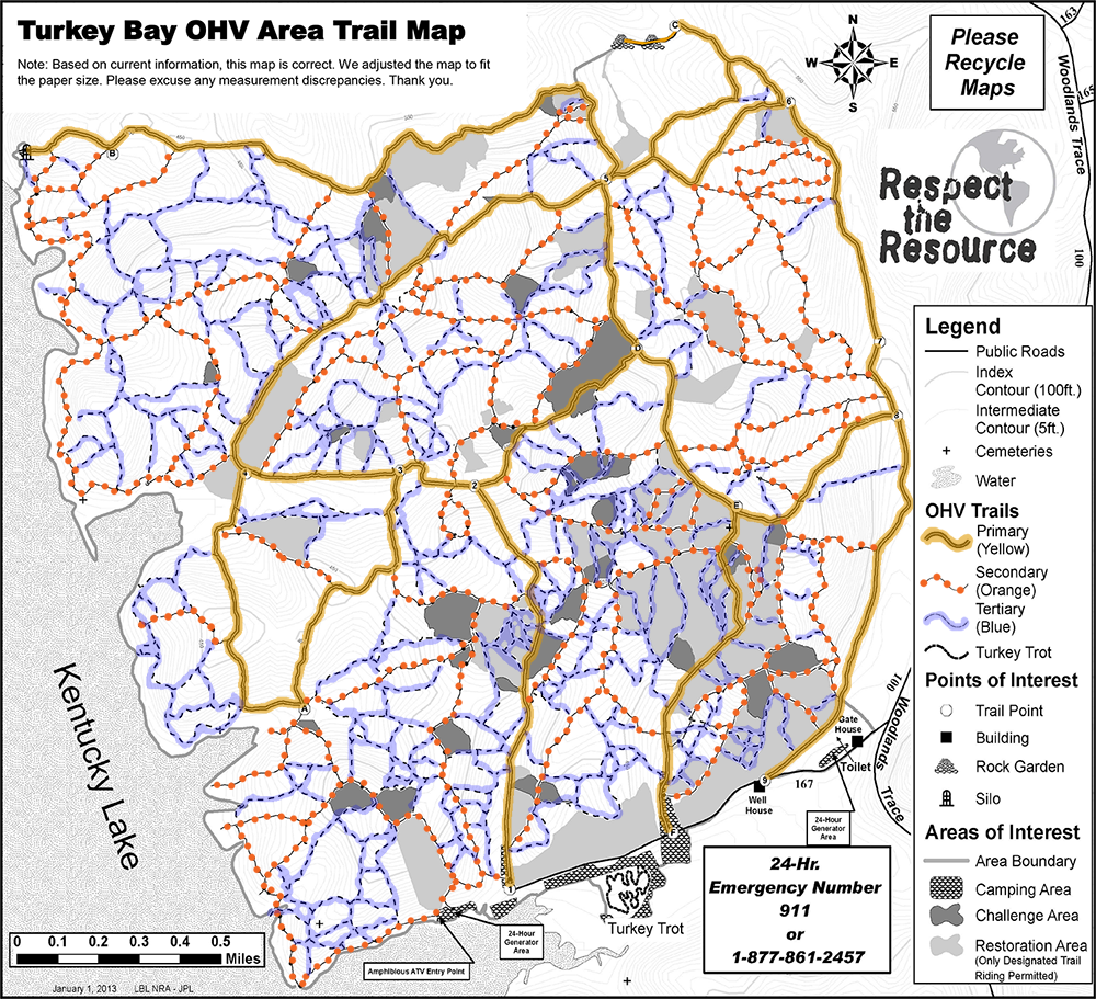
80 Turkey Creek Road, Golden Pond, KY 42211
Information at Golden Pond Visitor Center
W 88° 4’ 17.57” | N 36° 45’ 2.40”
270-924-2233
Riding Rules and Regulations
1. All riders are required to wear a U.S. Department of Transportation approved motorcycle safety helmet while riding or operating a vehicle. Exceptions include vehicles with a fully enclosed metal cab or roll bar protection and with functioning seatbelts.
2. Operators and passengers of motorized vehicles must fasten their seatbelts while the vehicle is in use. Exceptions include motorcycles and all-terrain vehicles (ATVs).
3. Riding passengers on vehicles not designed by the manufacturer to carry passengers is prohibited (36 CFR 261.55b). Passengers can only ride in vehicles built by the manufacturer to carry passengers; the vehicle must have an enclosed metal cab or roll bar protection and seatbelts. No aftermarket add-ons allowed (ex: bump seats).
4. Anyone under 18 years of age must have a parent or legal guardian’s signature to ride.
5. We require direct parental or adult supervision for all persons under the age of 16 operating an OHV (KY Revised Statute 189.515).
6. A person under the age of sixteen (16) years, when operating or riding as a passenger on an all-terrain vehicle, shall wear approved headgear, in the manner prescribed by the Secretary of the Transportation Cabinet, at all times that the vehicle is in motion. (KY State Law 189.515 6c)
7. No person under age 16 may operate an ATV with an engine size exceeding 90cc displacement. No person under age 12 may operate an ATV with an engine size exceeding 70cc displacement (KY State Law 189.515).
8. Law Enforcement Officers and Turkey Bay staff reserve the right to revoke riding privileges of any rider if misuse or inappropriate behavior occurs.
9. All users must enter and exit Turkey Bay by way of Forest Service Road #167 off Woodlands Trace. All other accesses are prohibited.
10. Kentucky state law prohibits public consumption of alcohol.
11. Operate OHVs from sunrise to sunset only. We post legal riding hours at the gatehouse daily.
12. All OHVs must be registered with Land Between the Lakes before use in Turkey Bay OHV Area. The permit sticker must always be properly displayed on the registered vehicle. Permits are not transferable between vehicles. When the gatehouse is staffed, permits can be obtained there. When the gatehouse is not staffed, riders must obtain a permit from the Golden Pond Visitor Center- open all year, 9am-5pm.
13. No exhibition riding permitted.
14. Speed Limits: 15mph on entrance road; 10mph in camping and unloading areas
15. All vehicles and operators must follow all state and federal laws.
16. OHVs must have properly functioning spark arresters and mufflers. Noncompliance will result in removal of permit and riding privileges.
17. Respect all “closed to riding” restoration areas. Responsible riding ensures future riding.
18. Operating a vehicle in a manner that damages, mutilates, or removes any natural feature or other property is prohibited (36 CFR 261.9 a and b). This includes mudding, mud bogging, or creating new trail and travel is strictly prohibited.
19. Stay on designated trails. If a trail is not marked, it is not a legal trail, and travel is strictly prohibited.
20. Users must remain within the boundaries of Turkey Bay OHV Area. The water’s edge serves as the western boundary.
21. Operating any all-terrain vehicle on a Forest Development Road outside of Turkey Bay OHV Area is prohibited (Forest Order 60-11-17, 36 CFR 261.13). “All-terrain vehicle” is defined as any motor vehicle used for recreational off-road purposes. This includes but is not limited to: side-by-sides OHVs and 4 wheelers regardless if state licensed.
22. Golf carts are not permitted in Turkey Bay OHV Area.
23. Pack it in. Pack it out. Litter laws strictly enforced; Dispose of oil and hazardous chemicals properly. Trash bags available at gatehouse upon request.
Amphibious ATVs
1. There is only one legal point of entrance and exit for personal water craft and amphibious ATVs at Land Between the Lakes in Turkey Bay OHV Area. You will find this point depicted on the Turkey Bay OHV Area Map.
2. To enter or exit land and water, you must go back to the designated launch point.
3. All users of this landing are required to register their vehicle at the Turkey Bay Gatehouse via Road 167 immediately upon arrival.
4. Only ATVs made by the manufacturer to be operated as an amphibious ATV may enter the water. All Rules and Regulations apply to amphibious ATVs when operated in Turkey Bay OHV Area.
5. The lakeside boundary fluctuates with the summer and winter pool lake levels. The water’s edge serves as the western boundary to Turkey Bay.
Camping at Turkey Bay
During your stay with us, please help provide a safe, quality experience for all our visitors.
1. Fires allowed at campsites only. You must attend to your fire at all times. Extinguish campfires before you leave.
2. Please maintain a clean campsite.
3. Quiet hours are from 11 p.m. to 6 a.m. No generators during these hours, except in designated 24-hour generator areas.
4. Avoid excessive riding in or near campsites.
5. Campsites are available on a first-come, first?served basis. Saving camping spots and roping off areas is not permitted.
6. Regulations for Dispersed and Basic Camping Areas apply. Camping units may not be left unattended for more than a 24-hour period without permission (36 CFR 261.16).
7. All camping must be in a designated Turkey Bay OHV Camping Area.
8. An honor fee system is located next to the gatehouse for after-hours camping registration.
Camping: $12 per camping unit per night
Two-24 hour generator areas, chemical toilets, and drinking water are available. Ice is available for purchase at the gatehouse.
Camping registration is self-service at the information kiosk in front of the gatehouse.
Camping is not permitted outside of the designated camping area.
Showers available at Wranglers Campground for a fee. Wranglers also has a seasonal Outpost with limited supplies for purchase.
Annual OHV Permit: $100 — valid from date of purchase to December 31 of current year.
1- to 3- Day OHV Permit: $20 — valid for three consecutive days after date of purchase.
All permits are non-transferable.
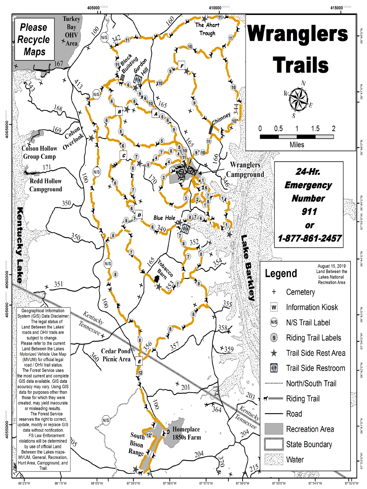
Wranglers Horse and Wagon Trails
Wranglers Campground and its 100-mile network of horse trails offers some of the most scenic spots at Land Between the Lakes National Recreation Area.
Bordering Lake Barkley and beautiful Fords Bay on the east and nestled between Laura Furnace Creek and Lick Creek on the west, it’s the only place at Land Between the Lakes designed for horseback riders and horse-drawn wagons.
White-tailed deer, wild turkey, hawks, native plants, wildflowers, unique historic sites and a shoreline teeming with waterfowl are just a few of the pleasures you’ll find along our trails at Wranglers.
| DETAILS | FACILITIES | NOTES |
| Guided trail rides: Rocking U Riding Stables offers guided trail rides on the hour for 45 and 90 minutes April through October. | 220 well-defined sites — some with electrical hookups, sites with electric, water, and sewer, primitive sites, and 12 primitive cabins available for nightly rental.
Most sites are capable of handling large motor homes and horse trailers. Campers have access to modern facilities, 100 miles of horse trails, activity court, and stalls, plus farrier and blacksmith services on weekends from April through November. |
All overnight campers with horses must camp at Wranglers Campground.
Camping with horses anywhere except Wranglers is strictly prohibited. |
Trail Map (Download PDF)